I set out to followup on the two articles I'd written after the attack on KDF in El-Adde, Gedo, Somalia.
Initially I''d hoped that with time the GOK would shed light on what happened, so there wouldn't need to be endless speculation on what happened as is wont to happen online where #KOT are involved.
I've been extremely curious to find out how ALS got the better of KDF given everything that's happened in Somalia since 2011.
I wrote two articles El Adde a name that will live in infamy & El Adde you won't forget that name in this lifetime in the latter article I raised a few questions about
- Base Construction
- Supplies
- Combat Support
- Crisis Management
Based on information available freely and widely on the internet and correlating that with news articles on the attack I'm following up on Base Construction.
I believe I did find the base in that may have been attacked by ALS in El Adde and based on what I raised in my second El Adde article I found the answer to some of the questions I raised.
.
If this isn't the El Adde base, it's still a military encampment and it's construction does raise some questions.
.
If this isn't the El Adde base, it's still a military encampment and it's construction does raise some questions.
Sources: Based on online articles including ones from The Daily Nation, The Standard and The Star, rescue missions were mounted from El Wak & Damasa in Kenya in response to the attack and surviving soldiers took refuge in a nearby town.
The rescue columns encountered IED's on the road between El Wak and the camp slowing them down. Some soldiers were rescued near the border, others were killed together with a family that sheltered them in the town near the base that was attacked.
With time some things about the attack have become clearer and some things still remain for now unknown.
 |
| Image 1 |
Searching outward from the town I found just north of the town at a distance of 0.97 kms what can be called an organized encampment
 |
| Image 2 |
Taking everything into account I examined this discovery further.
It's important to note that with Google Resources you're able to zoom back & forth through the image catalog over time and that's what I did.
The encampment has multiple rings of excavations and a full enclosure, there's one way into an out of the camp. It looks like a fortified military installation.
 |
| Image 3 |
Image 3 You can clearly see the road from the town to the encampment.
Image 4: The latest image shows two circular encampments a smaller one and the larger more organized one.
News articles have clearly stated that the El Adde KDF encampment is accessed through a SNA encampment as is the case in Image 4. The only access road to the larger encampment is through the smaller encampment.
 |
| Image 4 |
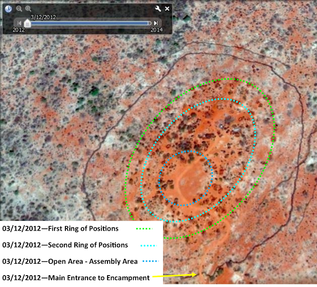
Going back to the earliest images of the area Image 5 & Image 6 which were taken on 03/12/2012 we notice a few things.
 |
| Image 5 |
Image 5: 03/12/2012 notice the general dryness of the are represented by the white and gray colors which is dry vegetation. The color of the earth where it's visible is pale orange.
Inside the enclosure which seems to made of vegetation of some kind, it's lighter than the trees (meaning dryer) but darker than the grass. This means in height it'd be shorter than the trees but higher than the grass.
Going back to the color of the earth on the you'll notice within the encampment that there are oval rings of excavations - a hole surrounded be dark red earth. You'll notice the ones to the south (nearer the town) are drier (older) and the ones to the north of the encampment are darker meaning the earth in those excavations is fresh compared to the ones in the south. In addition the excavations in the outside circles are drier than the ones in the inner circle.
My conclusions on the excavations are that they are Defensive Fighting Positions, Crew Served Weapon Positions and earth works raised around buildings to protect them from incoming fire.
It's also important to note the entrance to the south towards the direction of the town and there are some old structures which don't have earth works around them.
In addition it's important to note that the perimeter fence has some gaps in it which are clearly foot paths in and out of the compound and in some areas these paths have been blocked with slightly darker (fresher) vegetation.
 |
| Image 6 |
Looking at these the oldest images, I believe there is clear evidence of a new and expanding military encampment in 2012.
I found more images from 2014 which will be in Part Two......
No comments:
Post a Comment