Let not those who lost their lives in those attacks and the aftermath (from both sides) not have lost their lives in vain.
There's another piece of information that contributes to the evidence that this camp is a place that may have been over run in the El Adde Attacks.
Some Maths: In various news stories we've be told that when air support ( fast jet's) was dispatched from Nanyuki it arrived on station over El Adde in 30 - 40 minutes. That's an interesting time frame and allow me to explain why.
The current main fighter of our erstwhile air force is the F-5E Tiger II, which has a combat radius of 1039 kms. Combat radius is the distance a plane can fly from it's base accomplish an objective and return to base before tanks run dry plus minimums. Minimums is the amount of extra fuel a pilot needs to arrive over their destination with in case of any issues over the landing site.
The camp is exactly 550kms from Nanyuki which means that an F-5 would reach Nanyuki in just under 30 minutes and be able to loiter on station for 30+ minutes before having to return to Nanyuki before it's tanks ran dry.
With an available carrying capacity (payload) of 3.1 tonnes of weapons or extra fuel (extending the range) which if it was all used for weapons in air to ground mode (as I suspect happens in most missions in Somalia) would make for a long day for the individuals on the receiving end of those weapons.
Moving forward the next available images we have a date of 12/22/2014 - these are the last available images online for this area. There are no images for 2015 & 2016.
 |
| Image 7 |
Image 7: The encampment still exists two years later with more buildings and no brand new earth works as seen in 2012.
You will notice that the area isn't as dry as it was when the last pictures were taken and a new encampment has grown and become attached to the main encampment.
Going clockwise around the image you will notice the following:
Smaller Encampment: This smaller encampment has grown around the main route into and out of the camp and is directly South of the encampment we're focusing on (in the direction of the town)
Open Space: an open slightly slopped area which could be used for training or exercise
Partial Walls: there are a number of partial walls and trenches to the left side of the images.
To the left of the image is also where you can see the remains of the previous perimeter wall or fence.
The camp has an sense of permanence to it as compared to the 2012 images.
The perimeter has been expanded compared to the 2012 and there is a open area between the perimeter and the first ring of buildings and positions.
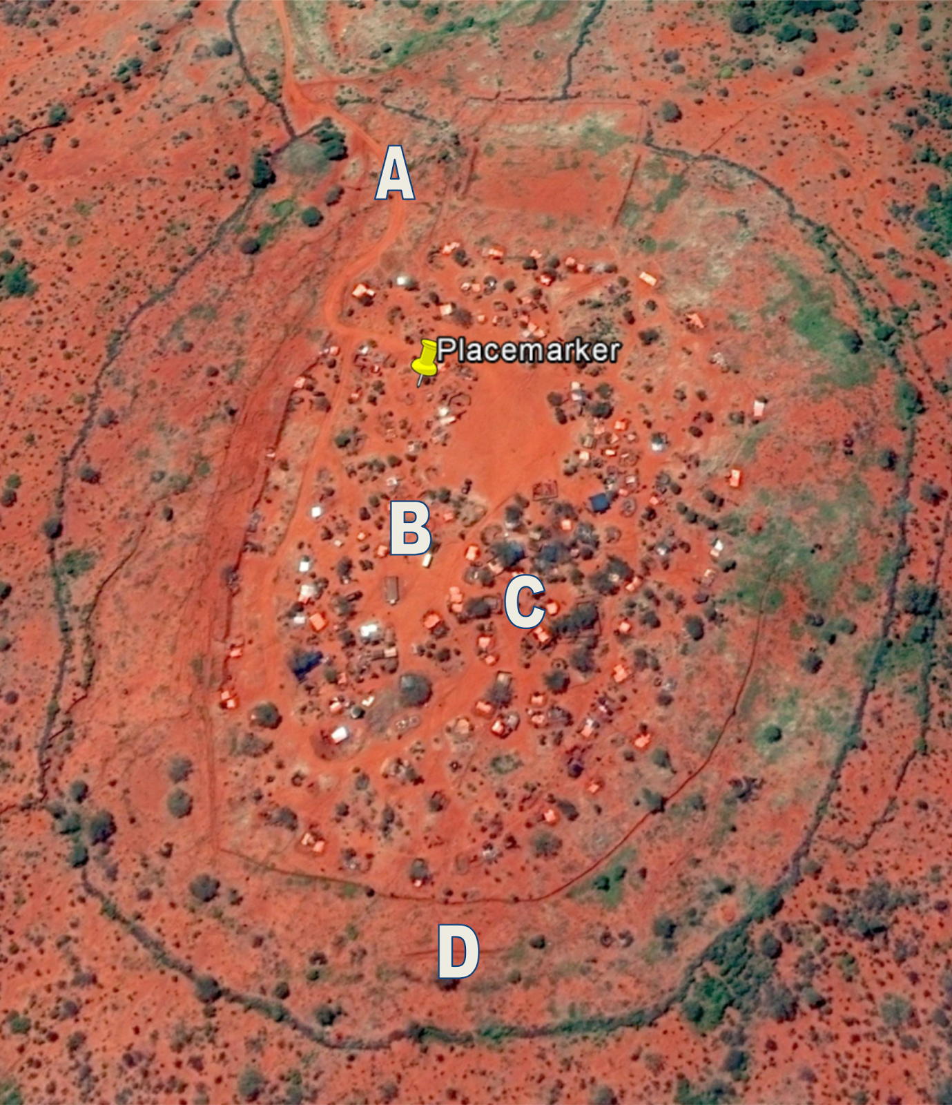
Lets focus on four different areas based on the 2014 images.
 |
| Image 8 |
 |
| Image A |
In this image we zoom in to the main route into and out of the encampment. You can see that there are two walls both of them unmanned in this image.
The first wall is the green fence which encircles the encampment and the second is narrower& defined by it's shadow it's almost the same color as the earth.
It's distinct shadow though does give an indication of it's height.
It's important to note that there don't seem to be any actual gates or sentry positions around either of these fences.
There are no shadows in the road to indicate barriers or a gate structure. There is a small shadow to the left just after the second wall which may be a sentry box. There are no obvious weapon positions around the gate although to of the structures at the bottom of the image could be weapon positions covering the gate.
In this encampment the gate structure isn't a secure space and neither is the one in the small encampment. Any attackers using VBIED's would be able to drive at speed into different sectors of the encampment.
In briefings after the attack we've been told how ALS was able to drive at least 5 different vehicles including VBIED's into the El-Adde encampment.
A gate entrance like this could explain how that happened.
 |
| Image B |
 |
| Image C |
Image B: you can see what seems to be artillery positions ( the ovals that look like they have watch hands inside them and one opening) these are field artillery pieces surrounded by an earth embankment - Crew Served Weapon (CSW) positions, I won't speculate on the caliber of these weapons. However in this image there are two of them. There is also what appears to be a vehicle parked near the lower CWS position.
There are at least four positions of the type in this image in various positions of this type around the camp which means that this encampment artillery fire support for itself and nearby military patrols (they point to the east and south east). It also means these weapons would be ranged (they would have calibrated these weapons to know what settings to choose to fire at targets 1km away or 10kms away). Which answers the question I raised on Mortar Batteries.
If this was the camp that was attacked and the attackers came through the smaller SNA camp and the defenders didn't know that the camp had been abandoned, they wouldn't have been able to use the weapons to fire at the direction the attackers were coming from. I raise this question because they should have been able to fire illumination rounds over the SNA camp and the road from the town and then plaster the approaches to the camp with rounds as fast as they could fire.
Image C: you can see several buildings with white roofs surrounded entrenched in the earth, it's possible that the walls of these buildings could have been built using Hesco Bastions (see El-Adde you won't forget that name in this lifetime) which means that the encampment inhabitants would have shelter from VBIED's unless it was parked right next to a building.
This is good, it shows the inhabitants knew how to fortify buildings.
Conclusion: from the images so far, we can see that the camp's defenses are heavier on the left side of the encampment - the eastern side. There are more walls and less vegetation compared to the right side of the encampment - the western side (it has less barriers and more vegetation). It may have been this is the area the enemy attacked from often.
The cardinal rule though, each side should have been as protected just as the Eastern side was. If encampment was attacked from the eastern side as a decoy and then the main attack came from the western side at dawn or dusk, it would be a confusing situation for the defenders.
 |
| Image D |
Image D lets look at the perimeter's. You'll see the outer perimeter at the bottom of the image (the green wavy line) it should have been made of thorn bush.
Next going upwards on the image we have the faint green line with a tree in it - this is the old perimeter from 2012, they moved the perimeter outwards. This area that we're in is called a free fire zone and should be absolutely vegetation fee to enable the defenders to shoot anything that crosses the perimeter.
Next we have what seems like a trench or temporary wall.
Lastly the final perimeter before you enter the encampment proper.
On average the distance between the inner barrier and the outer barrier ranges between 75 meters in the North and 90 - 99 meters in the East, South and West - this is good.
The only issue I have with this free fire zone is that isn't absolutely vegetation free. It's also impossible to tell if it's mined from these images. As well I feel the area outside the outermost barrier should have been defoliated for at least 50 meters. These imaged from 2014 do suggest a level of complacency on the part of the base defenders - it could be 15% complacency.
That 15% could be what get you killed when you face your adversary in conflict.
Conclusion
The defense features of this encampment aren't complete (to my liking) but it's not defenseless either. An encampment such as this wouldn't fall to attackers without any air support or artillery easily. It would be a tough nut to crack but still it would crack with the following:
- Surveillance: the attackers would need to have extensive surveillance of this encampment to determine it's weak points
- Access: the attackers would need access to the smaller encampment as a mini staging area to enable them to attack the larger encampment at speed and in numbers and to prevent the defenders from using artillery to impede their progress.
- Timing: there's a reason ALS attacks bases at dawn (Burundi, Uganda & now Kenya) dawn and dusk are the times of shadows, it can be hard to tell what is moving and not moving. This is why dawn and dusk in a base in an active war zone is the time to stand post - this means every one on base is armed and in body armor facing the fences watching everything and with flood lights on. This time normally lasts for around 30 - 45 minutes. In Africa as we know our sunrise and sunsets are quite fast. If the attacks began before 0530hrs then the defenders (with lights, night vision capability, artillery & the knowledge of the terrain) would have an advantage against an enemy with VBIED's, small & medium arms.
- Numbers: the attackers would have to commit a very large fighting force to overwhelm a encampment such as this and would face significant casualties no matter what they may claim afterwards.
Number 1 & 2 imply some form of cooperation from the locals around the encampment - it wouldn't be possible otherwise. The local populace is implicated if this encampment fell.
If this is the El-Adde Base of KDF there are some things I can and can't conclude - if it was to be attacked at the time these satellite images were taken.
First - what I can't conclude
If this is the El-Adde Base of KDF there are some things I can and can't conclude - if it was to be attacked at the time these satellite images were taken.
First - what I can't conclude
- I can't tell you if the defenders had night vision capability
- If night patrols were conducted from this encampment
- I can't tell you if they were standing post or about to stand post
- The competency & experience of the individuals at this outpost
- The defenses aren't all encompassing. There are glaring weaknesses that an enemy could exploit and use to their advantage in the right conditions
- This encampment is vulnerable through complacency in construction
- Step 1- 3 above would make a difference - a significant one
- This encampment has at least 200+ inhabitants
- This Base would fall if it was attacked at the time these images were taken
The last piece in this series is the El-Adde my post script.
At the very least should this turn out not to be an AMISOM KDF outpost then it's defenses could do with a lot of shoring up. Should it be an ALS encampment..... I won't take that thought to completion.
At the very least should this turn out not to be an AMISOM KDF outpost then it's defenses could do with a lot of shoring up. Should it be an ALS encampment..... I won't take that thought to completion.
No comments:
Post a Comment